History of Davisville
Earliest Inhabitants
The earliest known inhabitants of Davisville were the Wampanoag Native Americans. Wampanoag means “Easterners” or “People of the Dawn.” Historians indicate that the Wampanoag have a matrilineal system, in which women controlled property and hereditary status was passed through the maternal line. When a young couple married, they lived with the women’s family.
The Wampanoag named the Davisville area Pasnecoy – currently Davisville has a Pasnecoy Lane located south of the Menauhant Road between Davisville Road and Bournes Pond. Sea-faring Wampanoags travelled between the Cape and Islands for trade. Like current residents of Davisville, the Native Americans were attracted to the warm waters of the Sound and calm salt ponds. Abundance of fish and shellfish led to their establishment of this locale as a summer place.
Davisville’s MAGICAL CHARM
An excerpt from The Book of Falmouth, published in 1986, at the time of Falmouth’s Tri-Centennial celebration, and written by Davisville residents, Shelley Peirce and Jim Moor, about Davisville reads as follows:
“Unique because of its location between two tidal estuaries on the east and west, and with Vineyard Sound as its southern boundary, the village of Davisville provides a special charm for its year-round and summer residents. ‘Like all Gaul’, wrote our pundit, George Moses, ‘the village is divided into three parts: Davisville Beach, Davisville Village, and Davisville Road.’ Strolling through the leafy tunnel of maples on lower Davisville Road, the casual visitor admires the dignified old homes of varied architecture and the newer structures of modified Cape Cod styles. A discerning observer marvels at the grace with which the early builders reproduced houses in Greek revival design, distinguished by pilasters resembling columns, white clapboards, and off-center doorways – all without formal architectural guidance. The quiet community comprises a harmonious blend of the old and the new, a sense of stability, and a glimpse of the future. Just what is the magic that attracted the early tribes to the region, enticed the Davises and Bakers to settle there, led to the influx of enterprising Portuguese-Americans, impelled numerous families to establish roots in the village, and lured their children, grandchildren and, yes, even great-grandchildren to return to this serene haven?”

1930s: 473 Davisville Road.
Coast Guard. Lt. Com. Carl C. Von Paulsen pilot. Woods Hole 1926. Landed in Bourne’s Pond chasing rumrunners.
Falmouth’s coastline provided plenty of secluded landing spots for rumrunners, as can be seen in this aerial photo, taken 1964.
1915: Shows the rural character of the Davisville and Menauhant neighborhoods at that time.
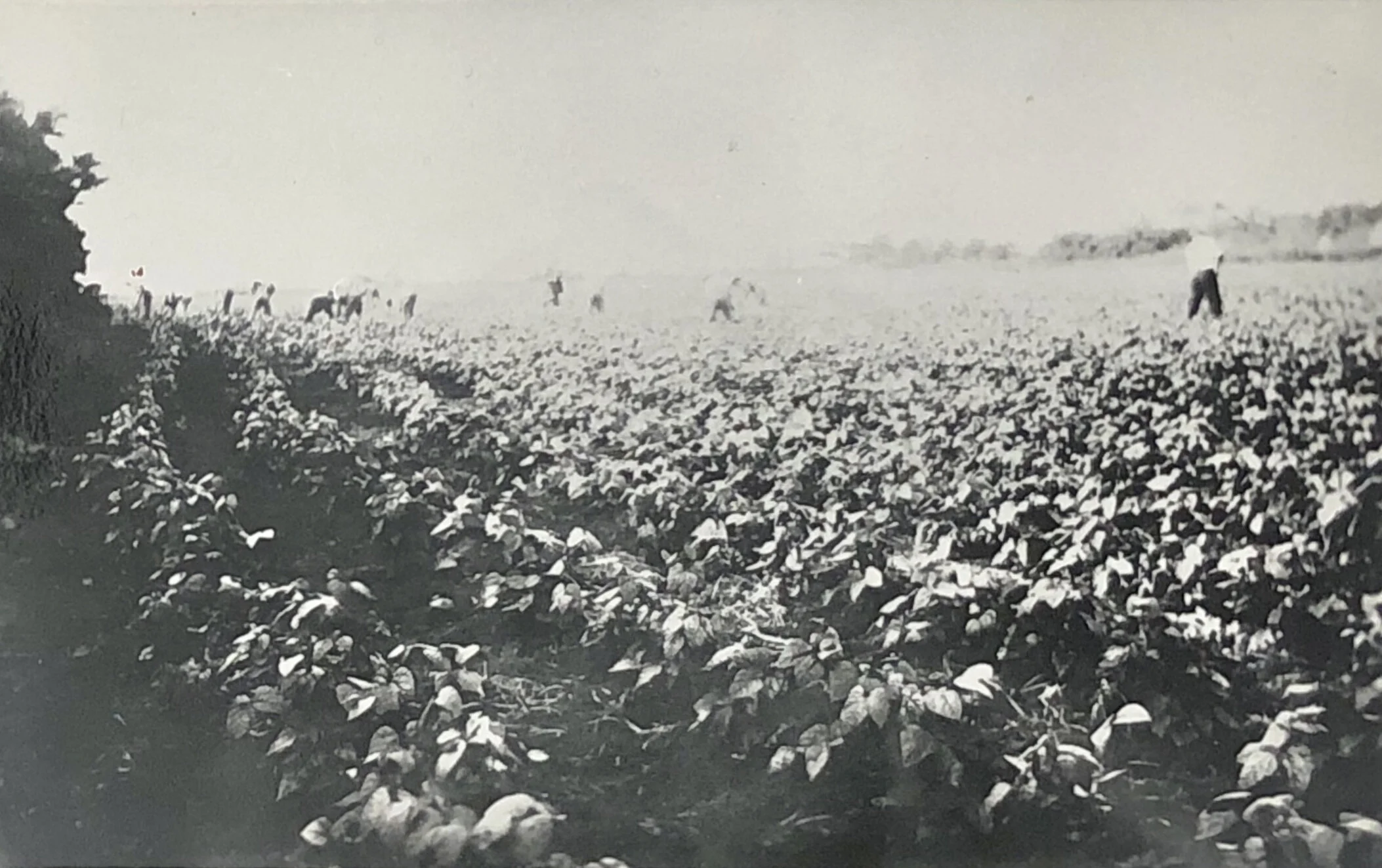
Early 1900s: Working in the turnip fields.

447 Davisville Road, circa 1885.

Davisville, STRAWBERRIES AND IMMIGRATION
Davisville Beach in the middle 1930’s: Draper Pier (Captain’s House) in the background at Old Bourne Pond Inlet; and the old fashioned “cradle jetties.”
The northern half of the Davisville peninsula played an important role in the history of Falmouth, in terms of both growing strawberries and immigration.
John Emerald, a Portuguese immigrant, in the early 1890s found some discarded strawberry runners and planted them in the sandy soil of Davisville. The strawberries grew exceptionally well and thus began the history of strawberries in Davisville and Falmouth generally.
Portuguese first came to Cape Cod and the Islands aboard whaling ships that had stopped in the Azores for additional crew and provisions. Once the whaling days were over, many Portuguese immigrants settled in the New Bedford Massachusetts area. With an agricultural background, many of these immigrants moved to the country and found John Emerald’s Davisville strawberry growing success very attractive.
By the 1920s and 1930s, strawberry growing in the Davisville area was a very successful enterprise. The four-week strawberry harvesting period each year required many pickers, with many of them being Cape Verdeans.
Most of the growers and pickers had a Catholic Church background. In the early 1920s, the diocese gave permission to raise money to build a church. It was named St. Anthony’s for the patron saint of the Azores, St. Anthony. Services were in their native language, Portuguese. In the community, St. Anthony’s Church became known as ‘the church that strawberries built”.
In the 1930s, Falmouth had about 600 acres of strawberries, with more than 3,000s brought in for harvest. Falmouth’s population at that time was only about 5,000.
Falmouth was known worldwide for its several varieties of strawberries which were successfully grown in the town’s rich medium loam soils. In 1937, Falmouth produced 13 million quarts of strawberries – 50% of all the strawberries grown that year in Massachusetts.
Subsequent to World War II, for many reasons, the growing of strawberries in Davisville began to decline. One major reason was the flourishing demand for housing and the appreciation in land values in Davisville. These strawberry fields are now lots for year-round and seasonal homes.
Please note the aerial photographs of Davisville Road in 1950 (basically all strawberry fields) and in 1988 (mostly housing lots).
When you eat your next strawberry shortcake, think of Davisville!
Davisville & World War II
Those of us who live here in Davisville, either seasonally or year-round are able to enjoy this area because of the freedom we have in this country. We are now approaching the time when most of military from the Second World War have now passed. We owe our liberty to those who fought on our behalf, many of which gave their lives to protect us during that time.
Did you Know?
Davisville and the especially the surrounding area of Washburn Island in our neighboring Waquoit Village of Falmouth played a key role in these war efforts. The attached editorial from the Falmouth Enterprise, dated June 16, 1944, twelve days after the D-Day Invasion of June 4, 1944, describes this in significant detail. It is interesting to note that the First Division was the first infantry division trained to storm a land objective from the sea.
These invasions took place in North Africa, Italy, and the most famous of all in Normandy. Many of these heroes were trained right here on the neighboring beaches of Washburn Island in Waquoit.
Also, subsequent to the damaging Hurricane in September 1944, German Prisoners of War, housed at Camp Edwards, were involved in clearing debris, here in Davisville. The Enterprise published an article entitled “The Cradle of Invasion” on June 16, 1944.

The original East Falmouth Post Office at Stevens Store was located at the northeast corner of the Route 28 and Davisville Road intersection.

Early 1900s: Davisville Road Extension.

1930s: Davisville Road heading north.

1930s: Menauhant Road leading to old wooden Menauhant Bridge.
Davisville Considered a Resort CommunitY
The map below shows the late nineteenth century summer colonies of the upper Cape. The greatest concentration of the Cape’s early resort development appeared on Buzzards Bay and the Sound side west of Hyannis. It’s impressive that “Davisville” is grouped with other early resorts of very esteemed "pedigree" such as Penzance Point, Gray Gables, Wianno, Oyster Harbors, Osterville, and Wings Neck.

Map artwork extracted from Becoming Cape Cod: Creating a Seaside Resort, by James C. Connell, University Press of New England, Hanover and London, 2003. (Cape Cod Commission, Geographic Information System Department).